Photo research and documentation
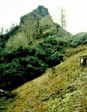
That remote and hard accessible fortress Karpu Kale near the spring of the famous Thermodon is nearly unexplored.
By launching this project we want to make this enigmatic place better known, and we intend to show the special significance of this site for our history.
Research situation:
=> Research campaign 1987
=> Research campaign 1999
We invite adventurous people who are interested in archaeology to take part in this new research project.
We are addressing local people who are living in the Samsun area, as well as adventurous people from farer away who are going to visit this fortress. Make own investigations there, take photos and send them to us. It would be a great assistance to us. These photos will be published on our web-site (with the name or pseudonym of the owner or anonymously if wished).
Location:
The ruins of Karpu Kale you find in the region of the administrative district Salıpazarı which is part of the northern Turkish province Samsun. The town Salıpazarı is about 50 km southeast of the provincial capital Samsun and 18 km southwest of the town Terme. Karpu Kale is located at about 800 meters above sea level near the village Konakören Köyü, approximately 12 km south-southeast of Salıpazarı.
Exact position: 41° 1′ 94.62″ N, 36° 89′ 75.63″ E
We are looking forward to your photos!
Diese Seite gibt es auch auf deutsch
Copyright © Amazon Research Center